FRIENDS AND NEIGHBORS OF DESCHUTES CANYON AREA
  • Home
  • HIKES & ADVENTURES
    • 2024 Guided Hikes
    • Night Sky Adventure recap
  • Stewardship
    • Land Stewardship
    • Recent Projects
    • Nest Monitoring
  • EDUCATION
    • Lens on Learning
    • Native Plants Interpretive Garden
    • Weed Consultations
    • Wildlife Focus
  • ABOUT US
    • Board Members & Coordinators
    • FANs merchandise
  • RESOURCES
    • Exploring the Area
    • SCENIC VIDEOS
    • Related Links
  • ORDER BOOKS

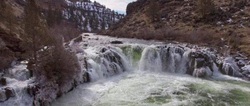
Directions to the Steelhead Falls Trailhead and Campground

Picture
From Highway 97 in Terrebonne, turn west on Northwest Lower Bridge Way. Proceed a little more than 2 miles, then turn right on Northwest 43rd Street, following signs to Crooked River Ranch. Take 43rd about 1.8 miles to the "T" at Chinook Drive. Turn left on Chinook Drive, then proceed just less than a mile and turn left onto Badger Road. Take Badger Road to its terminus at Quail Rd and turn right. Follow Quail Rd. for less than half a mile to River Road and turn left. Proceed on River Road downhill to the Steelhead Falls Trailhead. The Steelhead Falls Campground is just south of the trailhead parking area.

Powered by Create your own unique website with customizable templates.
  • Home
  • HIKES & ADVENTURES
    • 2024 Guided Hikes
    • Night Sky Adventure recap
  • Stewardship
    • Land Stewardship
    • Recent Projects
    • Nest Monitoring
  • EDUCATION
    • Lens on Learning
    • Native Plants Interpretive Garden
    • Weed Consultations
    • Wildlife Focus
  • ABOUT US
    • Board Members & Coordinators
    • FANs merchandise
  • RESOURCES
    • Exploring the Area
    • SCENIC VIDEOS
    • Related Links
  • ORDER BOOKS